
- Apply
- Visit
- Request Info
- Give

Stores, analyzes, and displays spatially oriented data to improve decision-making. The key to the rapid growth of GIS is its ability to integrate data and to model complex physical processes. Environmental scientists are using it for applications such as environmental impact analysis, hydrological modeling, and biodiversity studies.
*At least two additional courses approved by GIS Coordinator
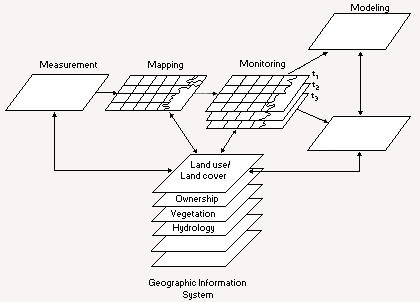 Since the beginning of the environmental movement during the 1970s, scientists have grappled with the complexity of environmental problems. Initial attempts to integrate the diverse nature of environmental information through manual overlays was only partially successful. The advent of more powerful computers gave scientists the opportunity to model these complex interactions through geographic information systems (GIS).
However, a GIS is less about using computer hardware and software than learning how to think spatially. The most important part of the system is the analyst's ability to recognize and understand spatial patterns. For example, a typical problem is analyzing the relationship between hydrological systems and riparian habitats.
What happens to riparian habitats when the hydrological regime is affected by a dam? What is the size of a buffer system that would limit the amount of pollutants migrating to the stream? How do you model these interactions to suggest alternatives that would maintain the integrity of the system? These are typical "what if" questions that can be asked using GIS.